

Beyond our borders
Last updated 2/15/2022 at Noon
Bill Bartlett
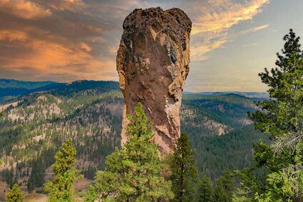
Steins Pillar in the Ochocos.
What part of “Stay Off The Trails When Muddy” do folks not understand? The signs at the most trafficked of our trails posted by Sisters Trail Alliance (STA) could not be more explicit. I used to think it was tourists who cavalierly blew past the markers unsure of their meaning. Now it seems obvious that many locals are wantonly disregarding their role as good stewards of possibly our most prized asset.
There. It’s been said. Somebody had to call it out. The imprints of shoes, paws, and tires are deeply etched in our trails. Just stop. For a while it was easy – just get on the path in the morning when the ground was frozen from overnight. But with these May-like temperatures in February the past few weeks, trail beds are not freezing. So, go higher. Get above the thaw line.
People have no idea of the work involved to smooth out rutted trails, volunteers from STA tell me. And we’re talking a lot of tails. Miles and miles. Most of the offenses are on the Peterson Trail system.
Speaking of trails. When you want to get out of our playground, head east. It is drier when you leave the pondos and get into the junipers of the Ochoco National Forest. Virtually no muddy trails just one hour away. Going west, over the pass, into the Willamette National Forest will for sure lead to wet or ice-patched now, so much of it being in the shade all day. And some of the most popular, like Proxy Falls and others off of 242, are closed for the winter.
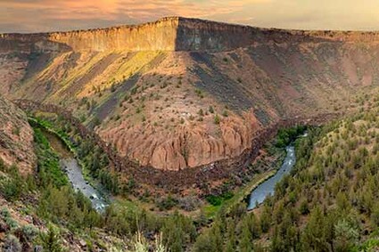
Not a hiker or biker but want a fab day out? Then take the leisurely drive from Prineville south on Highway 27 through the Crooked River Wild and Scenic Canyon, a top contender for the most jaw-dropping byway in Central Oregon. The basalt formations are impressive and overlook some of the best camping and picnic areas in all of Oregon.
You are guaranteed to find fly-anglers gently plying the river, great blue herons, and assorted other wildlife. Recent unseasonable days are even bringing out plein air painters and slow-water rafters. There are a dozen or more picnic sites and a bank- level viewing platform midway where, if lucky, you can see red band trout swim by.
Starting 8.3 miles from Prineville and running 17 miles upstream are 11 campgrounds in what is known as the Chimney Rock segment. There is only one hike in this segment and it bears its namesake. The Chimney Rock trail is a well-maintained, easy to moderate undertaking of only 2.6 miles out and back. The views are stunning and can be enjoyed with scattered gazing benches. The elevation gain is a gradual 665 feet. Dogs are welcome. Serious mountain bikers are infrequent to rare.
The whole of the frequently breathtaking gorge is under the management of BLM. Signage is fresh, with a number of truly informative interpretive kiosks illustrating the geology and wildlife of the area.
Just eight miles northeast of Prineville within Ochoco is another splendid hike, moderate in gain and length. Steins Pillar Trail is 3.8 miles out and back, gradually climbing 771 feet. February would typically be off limits due to snow. This is no ordinary February and old man winter could and will hopefully return soon for desperately needed precipitation.
For now the hike is giving up its snow yet some ice patches remain. Steins Pillar is a dramatic 350-foot formation named after Major Enoch Steen, who explored this area in the 1860s. His name was often misspelled and the misspelling stuck.
The canine-friendly trail starts flat then climbs, gradually reaching a viewpoint at a switchback where you can see the Three Sisters peaks. The trail levels off, then starts climbing again. Along the way are massive boulders.
Bill Bartlett
Go east and find drier conditions for hiking.
At about the halfway point, you will find a junction with a very short side trail to a viewpoint. Follow it to get the first glimpse of the goal, Steins Pillar towering above the forest. Around the two-mile mark, pass first one and then the next rocky formation on your left. Options are many including going to the base down some stairs, where the view is frankly obscured by the sheer bulk.
There are the lesser formations called twin or mirror pillars along the way, sufficiently majestic that some hikers have mistook them for the official Steins protrusion. Panoramic views similar to those at Chimney Rock are many with keepsake photo ops. On these many clear days, Mt. Hood is nearly as clear as Mt. Jefferson.
In all, there are at least seven hikes close to Prineville worthy of your consideration ranging from the moderate 1.5 Giddy-Up-Go trail to the difficult seven-mile Lower Lookout Trail or the nine- mile Wildcat Trail.
Give our trails a break for a while and trek east. You’ll be glad you did.


Reader Comments(0)