
New trail completed from Camp Sherman to Suttle Lake
Last updated 6/9/2010 at Noon
Craig Eisenbeis
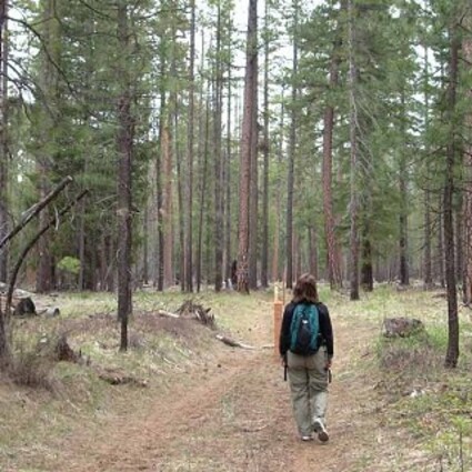
The new Lake Creek Trail from Camp Sherman to Suttle Lake often takes advantage of old logging roads. This section of trail passes through a mixed tamarack and ponderosa pine forest near the eastern edge of the Deschutes Land Trust’s Metolius Preserve.
It's not every day that we get a brand-new trail in the area; so, when I heard about the new Lake Creek Trail, a friend and I decided to try it out. Plus, this is in the snow-free zone, so it's a good early season hike that is easy and also suitable for trail bikes.
We decided to take the downhill direction and started at the Suttle Lake trailhead, which starts at The Lodge at Suttle Lake. We parked at the public area just across the Lake Creek Bridge. Officially, the trail begins at the lodge parking lot but can be picked up anywhere along the route.
The trail splits down both sides of the turnout near the bridge and rejoins itself a few yards farther downstream. The fork nearer the bridge hugs the creek and is more scenic. PGE and the Confederated Tribes of Warm Springs maintain a fish trap in this area to collect and tag ocean-bound sockeye salmon smolts.
One of the surprising features of the new trail is that it does not cross Highway 20. Instead, the path leads under the highway bridge over the creek, so there's no need to dodge high-speed traffic. For the first couple of miles, the trail stays pretty close to the creek; while the creek is not always visible, it's always within earshot.
Much of the route is over former forest roads; and, early on, the trail builders went to great lengths to obscure the old roads and meander the trail along the former road beds. Closer to Camp Sherman, however, the character is simply more that of an old road.
More than a mile of the trail is within the boundaries of the Deschutes Land Trust's Metolius Preserve, and the trail was completed with the Trust's cooperation. An informational kiosk presents land trust information near the mid-point of the trail. As the trail leaves the eastern part of the land trust's preserve, it wanders farther away from the creek; and the creek is no longer a part of the forest experience from that point on.
There are no steep or rough sections; and the trail is nearly flat, with a gentle downhill slope following the streamflow. The entire route is designed to be navigable by bicyclists, and we encountered some already taking advantage of the new biking opportunity. Word of the new trail seems to have traveled quickly, and I started receiving questions about the new trail before I even had a chance to check it out for myself.
The trail's final touches and markers were completed, largely by volunteers, as part of the local Earth Day observance. The trail is very well marked with substantial posts. Whenever the landscape opens up or other paths diverge, the posts can usually be spotted and depended upon to guide the way.
This is certainly not a wilderness trail, and it is accessible by vehicle from a number of points along the way. It shouldn't be too many years, however, before natural vegetation begins to obscure the old road beds and give the route more of a natural forest appearance.
Certain portions of this trail are closed to horses, and equestrians should familiarize themselves with those closures. Generally, horses are permitted for the two miles west of the Metolius Windigo Trail. Signs in the land trust preserve frequently call for separation of horse, bike, and foot traffic. Further information can be obtained from the Deschutes Land Trust and from the Forest Service at the Sisters Ranger Station.
The eastern portion of the trail passes through a section of forest with many larch trees, also known as tamarack. Some of the biggest tamarack trees I've ever seen can be found in this area. Curiously, the bark of very large tamaracks closely resembles that of ponderosa pine, although the limbs and character of the tree trunks are usually quite different.
The larch (or tamarack) is the only conifer that sheds its needles for the winter. Brilliant green new growth needles are now sprouting. In the fall, the trees' needles will turn a bright golden hue before they are shed.
The entire distance of this hike is probably a bit over 4.5 miles and certainly no more than five, even with a little wandering and exploration. The eastern end of the trail terminates in Camp Sherman near a Forest Service sign explaining larch thinning in the area.
Ticks are already out and seeking springtime meals. So take appropriate precautions, and check yourself for the dangerous little pests when you return from any hike.
To reach the Camp Sherman trailhead, turn right onto Forest Road 14 about eight miles west of Sisters. The trailhead is located about 4.5 miles north, on the left (west) side of the road directly across from Sternberg Road (just north of the Camp Sherman Community Hall). The Suttle Lake trailhead can be reached by turning left off Highway 20 into the resort area about 12 miles west of Sisters. Follow the signs toward the resort and Cinder Beach; the trail can be found immediately across the Lake Creek Bridge.


Reader Comments(0)