
Ski touring to North Blowout Shelter
Last updated 2/26/2013 at Noon
Craig Eisenbeis
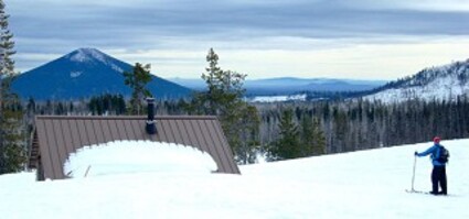
Looking east from the North Blowout Shelter, Black Butte is visible on the left and Cache Mountain on the right.
Not all backcountry ski touring involves long distances or wild, remote terrain. Here's a little excursion that is short, pretty easy, and readily accessible. There are a number of ways to reach the North Blowout Shelter, just south of Santiam Pass. The most commonly traveled route is from the Ray Benson Sno-Park.
We decided to take a slightly different approach and avoid some of the more heavily trafficked, and often icy, ruts that sometimes accumulate near the popular Sno-Park. Instead, we parked quite near the turnoff from Highway 20 that leads to Hoodoo and Ray Benson. There is a little pullout a short distance off the highway, and we were rewarded for choosing this variation by not seeing another skier, snowshoer, or snowmobiler for the entire outing.
The terrain leading into the shelter is mostly flat and open. While the marked trail was in good shape and easy to follow, we used it more as a "suggestion" and spent most of our time within sight of it but rarely on it. The ski trail also crosses the Pacific Crest Trail, which runs north-south through this area as it traverses the Santiam Pass region.
The section of forest is one of the many burned-over parts of the National Forest in our area, and often provides a clean, smooth surface, with few branches, tree wells, or other obstructions - save for the burned tree trunks standing starkly in the snow. However, this is also an area that is starting to see some of the (mostly) lodgepole pine seedlings poking up through the snow, a condition that will only become more noticeable in the years ahead.
There are a few short pitches of up- or down-hill and one peculiar spot on the trail that has a difficult sharp right turn at the base of a short hill. That might be one of those spots where leaving the trail would be worth your while. On the whole, though, this is a relatively easy jaunt. Also, it is very difficult to get lost in this area, since it is quite close to the highway. If a person were to feel lost, it is only necessary to head due north; and Highway 20 will be encountered within a mile or so.
North Blowout Shelter is a worthy destination. I am told the area was named for a nearby "blowout" of volcanic cinders. Built in the 1980s by the Willamette Chapter of the Oregon Nordic Club, the original shelter was destroyed in the B&B Fire of 2003. However, it was soon rebuilt and is once again the social destination that it was before the fire. The shelter sits on a high point and looks out across a scenic, if mostly burned, panorama to the east. Black Butte and Cache Mountain rise up in the near distance.
The shelter itself is well-constructed, with its inner walls lined with benches facing a nice wood-burning stove. This rustic little log cabin has a heavy canvas door and a large plexiglass window, and is kept stocked with firewood. On busy weekends, it can be a bustling congregating point for outdoor enthusiasts. On our weekday outing, however, the place was deserted. It was a beautiful sunny day; and inside, away from only a slight breeze, there was no need to build a fire while we enjoyed the lunch we packed in.
To return to Ray Benson or to our little pullout nearer the highway, it is not necessary to descend directly down the eastern slope that gives the shelter its splendid view. However, my friend wanted to explore around to the north, so that's exactly what we did. I did a bit of sidestepping and took some long switchbacks down the slope and made it down to the flats none the worse for wear.
Away from the trail now, we looped around to the north, crossing the main trail again and paralleling the old Hogg railroad grade before skiing across a frozen pond, eventually coming in behind the ODOT maintenance area, with its large mounds of sand and gravel. The never-finished railroad grade is a relic from an ill-fated 1888 venture and extends for several miles between Santiam Junction and the Old Santiam Wagon Road, which passes through the area about 2.5 miles to the south.
Even with our exploratory wandering, we probably didn't cover much more than about three miles. Another advantage to this location is the relatively high elevation. At a very nearly uniform elevation of 4,800 feet, the area is high enough that the snow conditions are better than most of the lower areas; and the snow cover will linger for months, providing some nice spring skiing, as well.
Snow conditions were quite good; and, everywhere we went, we found easy going and a very pleasant off-trail tour. The area is such that even beginning cross-country skiers can enjoy the area without feeling too stressed by the demands of the terrain. Inexperienced skiers, however, would probably do well to stick to, or close to, the marked trail system.
As always, however, backcountry travelers should not travel alone and should carry appropriate emergency equipment. Remember that weather and snow conditions in the mountains can change rapidly.
The starting point for this outing is easy to find, 20 miles west of Sisters on Highway 20. Turn left (south) at the sign for Hoodoo Ski Area, and park at one of the little turnouts or follow the signs to Ray Benson Sno-Park. Sno-Park permits are required for the area, except at Hoodoo's parking lot.


Reader Comments(0)