
Proxy Falls is an excellent fall hike
Last updated 11/3/2020 at Noon
Craig Eisenbeis
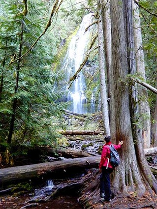
Lower Proxy Falls tumbles into a glacial valley off a short loop trail west of McKenzie Pass.
As we wait to see if the predicted La Niña actually comes to pass, I feel like the mountains are crying “Last Call” for hiking. So, we decided to take one last (maybe) trip over McKenzie Pass this year while we still had a favorable weather window. We selected Proxy Falls but then thought maybe we’d make more of a trip out of it and do the whole Santiam-McKenzie loop, so we added a couple of other stops along the way.
So, even though it’s only about a 27-mile trip to Proxy Falls, we managed to make it into about a 90-mile circuit, stopping at Fish Lake and Sahalie Falls along the way. Fish Lake, of course, is empty this time of year, so we got out and explored some of the lake bottom. I can remember kayaking here in the spring and looking down through the clear water as I glided above the submerged, but well-defined, trail tracing its way along the bottom of the shallow lake. This time, we walked it.
At Sahalie Falls, there are plenty of trails to choose from, but we just made a brief stop to admire the falls. It seemed to take longer than I remembered to get to the McKenzie Highway turnoff. The junction, after all, is on the other side of Belknap Springs. When we arrived at the Proxy Falls Trailhead, it was obvious that we weren’t the only ones to have that idea for a Saturday hike. There were 15 cars already there, and parking was limited.
Signs told us that this is a fee area; but, after I deployed my Golden Access Pass, we saw that there was a notice exempting passes this year. Kiosk directions suggest a counterclockwise pattern of travel on this loop trail in order to minimize contact with other hikers – an excellent idea in this COVID year, but not one that was universally adhered to. Probably fewer than half the hikers were using masks, but we were occasionally thanked by other hikers for using ours.
The entire loop trail is only about a mile, exclusive of the additional spur trails to the two falls themselves. However, as short hikes go, this one could be considered a little more difficult than some. The first part of the hike passes through and over one of the McKenzie’s trademark lava flows, necessitating some scrambling and awkward footing along the way.
Fall colors are past their peak, now, but were still in evidence during our visit this past weekend. When the trail plunges into the dense forest, huge old-growth Douglas firs dominate the forest but also shelter hemlock, Pacific yew, and western red cedar. Salal, sword ferns, rhododendrons, lichens, and thick green moss that completely covers much of the lava rocks make it clear that you’re on the west side of the mountains.
Lower Proxy Falls is the more photogenic of the two, but the upper falls has an interesting and unusual feature. Each waterfall has its own separate stream cascading from a cliff sheared off by glaciers thousands of years ago. The access trail to the lower falls is quite steep and very rough in places, occasionally requiring some hand-over-hand climbing over rocks and roots.
Upper Proxy Falls drops into a scenic pool, from which there is no visible outlet; so that stream just vanishes. As is the case in much of the McKenzie region, the lava flows have created porous substrata that redirect surface water to springs that reappear several miles away. The access trail to the upper falls is much easier to traverse than the lower, but the falls here are less impressive.
The exit trail on the back side of the loop is flatter and less obstructed than the scramble through the lava field on the way in, but you would miss the best of the cathedral-like dense forest if you opted to take that route both ways.
There are two snow gates at the west end of the McKenzie Highway; and, at only a little over 3,000 feet elevation, this trailhead is outside the upper snow gate. This means that, even though the highway over the pass will close with the first significant snowfall, this lower area on the west side will often remain open well into December and can be accessed via Santiam Pass. Later in the season, however, be sure to check local road conditions, as closure dates of the lower snow gate may vary significantly.
To complete our driving loop, we returned over a sunny and snow-free McKenzie Pass. I can’t help but be a little saddened each time I see the damage wrought by the Milli Fire on one of Central Oregon’s most beautiful areas.
As a matter of interest, the Linton Lake Trailhead is also (just barely) outside the lower snow gate, thereby extending the hiking season for that pleasant 3.8-mile round-trip hike. Linton Lake was formed in the same glacial valley as Proxy Falls and, like the upper falls, has no visible outlet. If you have the time and inclination, it’s a simple matter to do both the Linton Lake and Proxy Falls hikes on the same trip.
To reach Proxy Falls, simply head west on Highway 242 past Sisters High School over McKenzie Pass. The Proxy Falls Trailhead is about 14 miles beyond the summit. If McKenzie Pass is closed, take Highway 126 over Santiam Pass toward Eugene, and turn left (east) onto the western end of Highway 242 after Belknap Springs. The Proxy Falls Trail is about 9 miles east between mileposts 64 and 65.


Reader Comments(0)